SDIM‘s cooperative research and related achievements in 2014
December 30.2014
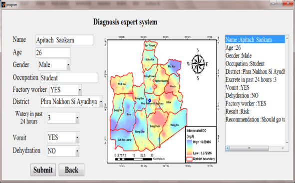
SDIM aims to lead collaborative research in developing countries that seek to increase the knowledge and capacity to use Earth observation technology for disasters early warning, preparedness, management, mitigation, and recovery. The Joint Research Program on “Space Technology for Disaster Mitigation in Asia” of SDIM has started since late 2013 and founded 11 projects with 7countries, including Mongolia, India, Pakistan, Thailand, Cambodia and Indonesia. This program focuses on several natural disasters mitigation such as drought, flood, stepper fires and tropical storm disaster, and strengthens cooperation research capacities for disaster mitigation through improving analysis methods and constructing proper data bank system sharing platform. In 2014, several key application systems have been developed by SDIM including CropWatch System, Agriculture & Disaster Mobile Monitoring System, SatSee System, Drought System and Diagnosis Expert System for Floods.
(1) SDIM developed the CropWatch system that can assess global, regional, and national (as well as sub-national) crop condition, production, and agricultural trends. In 2014, four CropWatch Bulletin were published and according to website statistics, CropWatch website visiting has exceeded 4000, with 751 independent IP, covering more than 30 countries in the word and all provinces in China.
(2) SDIM conducted collaborative research with Kirghizstan, to provide them with the interpretation of satellite remote sensing data for drought research. In September and November 2014,Prof. Zhumaliev, director of Kyrgyz National Academy of Sciences,visited SDIM to seek for further cooperation. Aiming to help Kirghizstan monitor and analysis drought conditions with remote sensing technologies, SDIM developed a newly application system called “Agriculture & Disaster Mobile Monitoring System (SDIM-ADMMS)”, which could provides in-site monitoring of agriculture droughts with mobile devices. This system has already applied successfully in China. SDIM also provided special training to their visit scholars in this field.
(3) SDIM has devoted itself to spread the economical Virtual Ground Station (SatSee System) to developing countries for disaster mitigation. SatSee system is initiated and developed by RADI. It is able to provide users with near real-time, full resolution quicklook images of remote sensing satellite data through internet and doesn’t require an antenna to be built on the users’ side. This service mode is expected to contribute to emergency monitoring needs like the disasters monitoring. In 2014, SDIM has successfully facilitated the transfer of this system to Kyrgyz.

DroughtWatch system co-developed by SDIM and Mongolian partner

Diagnosis expert system for floods co-developed by SDIM and Thai partner
Contact:
Tel: 86-10-82178959 86-10-82178074
Fax: 86-10-82178959
E-mail: sdim@ceode.ac.cn
Address: No.9 Dengzhuang South Road, Haidan District, Beijing
© Copyright CAS-TWAS AII Rights Reserved